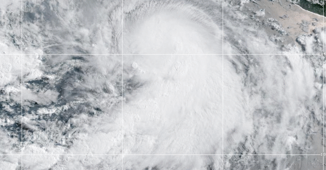
A tropical storm that formed off the coast of Mexico rapidly intensified on Wednesday to become Hurricane Adrian, the first named storm of the hurricane season in the eastern Pacific region this year.
The storm had maximum sustained winds of 80 miles per hour and was moving west at six m.p.h. Wednesday morning, according to the National Hurricane Center. Tropical disturbances that have sustained winds of 39 m.p.h. are given a name. Once winds reach 74 m.p.h., a storm becomes a hurricane.
As of Wednesday afternoon, Adrian was about 370 miles southwest of the coastal city of Manzanillo in Mexico, and was moving west and away from land.
Maria Torres, a meteorologist with the National Hurricane Center in Miami, said that the system would maintain the same general direction through Thursday and that it was expected to make a turn to the west-northwest on Friday.
The hurricane did not appear to represent an immediate threat to land, she said, adding, “It’s going to be remaining over open waters.” There were no coastal watches or warnings in effect in connection to it.
But she urged that people living along the coastal areas of Mexico should monitor the storm and updates from their local meteorology offices, “because it can create rip currents and hazardous beach conditions.”
Hurricane-force winds extended up to 10 miles outward from the storm’s center, and tropical-storm-force winds extended up to 60 miles, the National Hurricane Center said.
Whether a storm forms in the Atlantic Ocean or the Pacific Ocean, it generally moves west, meaning that Atlantic storms usually pose a greater threat to North America. When a storm forms close to land in the Pacific, it can bring damaging winds and rain before moving out to sea.
However, an air mass can sometimes block a storm, driving it north or northeast toward the Baja California peninsula and other parts of the west coast of Mexico. Occasionally, a storm can move farther north, as was the case last year with the post-tropical cyclone Kay, which brought damaging wind and intense rain to Southern California. Some Pacific storms even move across U.S. land; in 1997, Hurricane Nora made landfall in Baja California before moving inland and reaching Arizona as a tropical storm.
Hurricane season in the eastern Pacific began on May 15, two weeks before the Atlantic season started. Both seasons run until Nov. 30.
Complicating things in the Pacific this year is the likely development of El Niño, the intermittent, large-scale weather pattern that can have wide-ranging effects on weather around the world.
In the Pacific Ocean, El Niño reduces the changes in wind speed and direction that are known as wind shear. The instability of wind shear normally helps prevent the formation of storms, so a reduction increases the chances for storms. (In the Atlantic Ocean, El Niño has the opposite effect.)
Hawaii is in the central Pacific but is occasionally affected by storms that form to the east of it. It is unusual, however, for a named storm to make landfall in Hawaii, given that the land area is small and divided among several islands. The last hurricane to make landfall in Hawaii was Iniki, in 1992. In 2020, Hurricane Douglas produced damaging winds but did not deliver a direct hit to the state.
On average, the eastern Pacific hurricane season generates 15 named storms, eight of those hurricanes, and four becoming major hurricanes with winds that reach 111 m.p.h. The Central Pacific typically sees four to five named storms that develop or move across the basin yearly.
There is solid consensus among scientists that hurricanes are becoming more powerful because of climate change. Although there might not be more named storms overall, the likelihood of major hurricanes is increasing.
Climate change is also affecting the amount of rain that storms can produce. In a warming world, the air can hold more moisture, which means that a named storm can bring more rainfall, as Hurricane Harvey did in Texas in 2017, when some areas received more than 40 inches of rain in less than 48 hours.
Researchers have also found that storms have slowed down over the past few decades. When a storm slows down over water, it increases the amount of moisture the storm can absorb. When the storm slows over land, it increases the amount of rain that falls over a single location. In 2019, Hurricane Dorian slowed to a crawl over the northwestern Bahamas, resulting in a storm-total rainfall of 22.84 inches in Hope Town.
Research shows that climate change might have other impacts on storms as well, including storm surge, rapid intensification and a broader reach of tropical systems.
Eduardo Medina contributed reporting.


